 Obtained from: "Colville Indian Reservation" http://en.wikipedia.org/wiki/Colville_Indian_Reservation The Colville Indian Reservation is home to 12 constituent bands of Indigenous groups that make up the Colville Confederated Tribes. The reservation is situated, as demonstrated by this map, in north central Washington State, of the Pacific Northwest in the United States of America. The boundaries of the reservation are clearly defined by the bold maroon line. What I find interesting is westward of the reservation is a small maroon dot. The dot is situated where the Wenachee River and Icicle Creek meet and is representative of Trust Lands associated with the Colville Tribe. 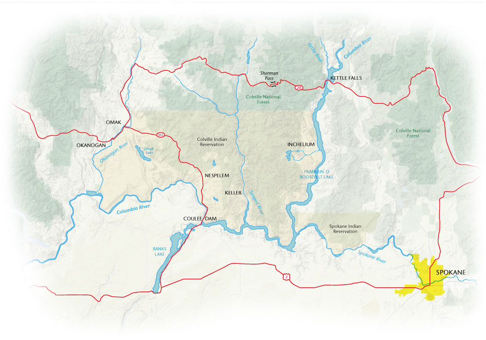 |
| Obtained from: "Washington State Magazine: The Law and the Land" http://wsm.wsu.edu/s/index.php?id=1000#.UkW_IiHn-Uk This map of the Colville Indian Reservation demonstrates the larger communities on the reservation, consisting of Nespelem, Keller, Inchelium, Omak and Okanogan that are on the boundaries and near the boundaries and within it. Additionally, the state highways are illustrated with the red lines. Highways are patrolled by Colville Tribal Police with agency assist from county, state and federal entities. Also demonstrated in this map are the various water resources. The Columbia River and the Okanogan River provide partial boundaries of the reservation. Four of the major lakes are also demonstrated on this map; Omak Lake, Buffalo Lake, Owhi Lake and the twin lakes to the east near Inchelium. This map also demonstrates proxemics to the neighboring Spokane Indian Reservation and the City of Spokane. |
 |
| Obtained from: "What is this? Top definitions & references about hobby, art, sport, health, culture, science and technology." Colville Indian Reservation Is... http://topdefinitions.com/2013/06/27/colville-indian-reservation-is/ This map provides more specific and detailed information such as highways, paved roads, and dirt roads. More of the smaller, rural communities are that are spread throughout the reservation are evident in this map. Chief Joseph Dam is located near the confluence of the Columbia River and the Okanogan River, however, the map does not identify the Grand Coulee Dam; which is situated on the Columbia River along side the community of Coulee Dam. Reservoir names are noted in this map which are Lake Roosevelt and Lake Roofus Woods. The reservoirs are direct results of the construction of the dams on the Columbia River. *For all intents and purposes, this blog has been created for assignment fulfillment regarding GEO 328 and is structured based on coursework requirements. |
No comments:
Post a Comment